Geographic Information System (GIS) Diploma
Best Saving Deal | 17-in-1 Premium Bundle | 185 CPD Points | Free CPD Accredited PDF Certificates [5,000+ Students]
Skill Up
Summary
- Certificate of completion - Free
- Hard copy certificate - £9.99
- Exam(s) / assessment(s) is included in price
- Tutor is available to students
Add to basket or enquire
Overview
✿ 17 in 1 "GIS" Bundle ✿
This GIS training offers :
- 17 Free PDF Certificates
- 1 Hard Copy Certificate for the Title Course.
- Free Assessment
- Lifetime Access
GIS is a rapidly growing field, with a predicted growth rate of 10% over the next five years. There are a number of leading GIS companies in the UK offering a range of opportunities for career growth. So, if you are willing to start your journey in this rapidly growing sector, our Geographic Information System Diploma will cover everything you need to know to get started.
This training has covered all the latest topics to keep you better prepared for your GIS profession.
This GIS Bundle Consists the Following Courses:
- ArcGIS for Spatial Analysis
- ArcGIS for Remote Sensing
- Create Smart Maps in Python and Leaflet Level 3
- Machine Learning for Predictive Maps in Python and Leaflet
- Web Scraping and Mapping Dam Levels in Python and Leaflet Level 4
- Maps in R Shiny and Leaflet
- The Basics of ArcGIS for Hydrology
- Learn to Use Python for Spatial Analysis in ArcGIS
- Python Programming Complete Training
- Archaeology Course
- Geology Course – Online & CPD Accredited
- CompTIA Network+ Certification
- Learn Secure Programming for Web Applications
- Ethical Hacking Masterclass
- Microsoft SQL Queries
- Project Management Complete Training
- Critical Thinking & Problem Solving
Enrol now for a successful GIS career!
Learning Outcome of this bundle :
- Recognise how to use ArcGIS for spatial analysis.
- Create Smart Maps in Python and Leaflet Level 3.
- Learn Python and Leaflet for Machine Learning for Predictive Maps.
- Know Python and Leaflet Level 4 Web Scraping and Dam Level Mapping.
- Study programming in Python.
- Acquire knowledge of secure programming for web applications.
- Learn about project management, Microsoft SQL, and ethical hacking.
CPD
Course media
Description
If you want to learn more about GIS in-depth, this GIS bundle is perfect for you. This package includes many courses that address all critical facets of GIS. You will gain the expertise and knowledge of the industry needed to advance your career in GIS.
Here is the course curriculum for the primary Title Course in this bundle:
ArcGIS for Spatial Analysis
- Point Density Analysis
- Raster Calculator and Vector Isolation
- Raster to Topography
- Raster Reclassification
- Raster Overlay
- Slope Analysis and Hydrology tools
- Introduction to TIFF Files
- Introduction to 3D Surfaces
- Satellite Images and TIN Surfaces
- Exercise
----------and 16 more Courses----------
_____________________________________________________________________________________________
Our Learner's Top Reviews:
- Varsha Sivamohan - “It was a great experience. The course was jampacked with excellent information. And when I needed help, Skill-up helped me with technical problems instantly. Fast feedback.”
- Charlie Anderson- “The support team was FANTASTIC!!! Very quick to respond and even though I was nervous as I am not good at tests, they made me feel comfortable. I am very grateful for the support”
- Aarini Sinha - “Amazing workshop. Very informative for the freshers like me. Learned a lot of things about digital marketing. I'm really thankful”.
Over 100+ glowing reviews.
_____________________________________________________________________________________________
Assessment
After completing all the modules of the GIS, your learning will be assessed by an assignment or multiple-choice based exam. You may choose to participate in a Mock Exam before attending the bundle completion Final Exam with no extra cost.
Who is this course for?
This GIS training is open to everyone.
Requirements
For this GIS bundle, you don't need any formal qualifications.
Career path
Some popular professions in GIS include,
- Database administrator
- Technician
- Cartographer
- Map artist
- Geospatial engineer
The average salary for a Geographic Information System professional in the UK is £50,000.
Questions and answers
Do you need access to GIS software in order to do this course?
Answer:Dear Hugh, Yes, the software is required to do the course.
This was helpful.
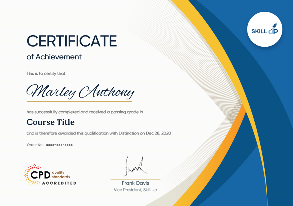
Certificates
Certificate of completion
Digital certificate - Included
This GIS Bundle comes with FREE CPD Accredited PDF certificates, making this an excellent value for money.
Hard copy certificate
Hard copy certificate - £9.99
Receive a free CPD Accredited Hard Copy Certificate just for the Title course.
The CPD Accredited Hard Copy Certificate for additional courses can be ordered separately for £9.99 per copy. The delivery fee for the hardcopy certificates, however, is free for UK residents, whereas it costs £10 for international students as delivery charge.
Reviews
Currently there are no reviews for this course. Be the first to leave a review.

Add to basket or enquire
Course provided by
Legal information
This course is advertised on reed.co.uk by the Course Provider, whose terms and conditions apply. Purchases are made directly from the Course Provider, and as such, content and materials are supplied by the Course Provider directly. Reed is acting as agent and not reseller in relation to this course. Reed's only responsibility is to facilitate your payment for the course. It is your responsibility to review and agree to the Course Provider's terms and conditions and satisfy yourself as to the suitability of the course you intend to purchase. Reed will not have any responsibility for the content of the course and/or associated materials.
